Long before its formal creation as an independent province, Quirino was the forest region of the province of Nueva Vizcaya, inhabited by tribal groups known as the Negritos. They roamed the hinterlands and built their huts at the heart of the jungle.
Quirino lies in the southeastern portion of Cagayan Valley. It is situated within the upper portion of the Cagayan River basin and bounded by Isabela on the north, Aurora on the east and southeast, and Nueva Vizcaya on the west and southwest.
The Ilocano dialect is used widely in the lowlands of the province’s various municipalities while Ifugao is predominant in the uplands.
Geography
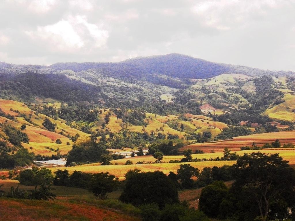
The Sierra Madre Mountain Range provides a natural barrier on the eastern and southern border of the province and the Mamparang Range on the western part. The province is generally mountainous, with about 80 percent of the total land area covered by mountains and highlands. A part of the province’s comparative advantage is its accessibility to the town of Aurora.
Industries
Agriculture is the main industry with rice and corn as major crops. These supply the demand of neighboring provinces and the metropolis. Banana, as well as banana chips are major products sold in Metro Manila and Pampanga. Small-scale industries like furniture making, basketry, rattan craft, and dried flower production are prevalent.
Profile
Carved from out of the region where the headwaters of Cagayan River descend to the Cagayan plains, Quirino is the newest of the five provinces in Cagayan Valley. It composes the municipalities of Aglipay, Cabarroguis, Diffun, Maddela, Nagtipunan and Saguday. The province lies in the southern portion of Cagayan Valley, bounded by Isabela on the north, Aurora on the Southeast and Nueva Vizcaya on the west. The Sierra Madre Mountain Range runs along the border with Aurora while the Caraballo Range dominates the southwest. About 80% of its area is mountainous. The flat lands of the northwest form part of the Cagayan Valley plains. It is here that the main population centers are found. There is no marked rainy season although the province is dry between the months of December and May.
History
The area that covers what is now the province of Quirino was part of the range of Ilongot tribesman who hunted and practiced upland agriculture. The Spaniards incorporated the area into the province of Cagayan in the late 16th century and it remained part of that province until 1839, when it formed part of the province of Nueva Vizcaya. In 1856, much of what presently corresponds to the province of Quirino was incorporated into the province of Isabela. The Spanish government created the comandancia of Binatangan, which was attached to Isabela, to administer the headwaters of the Cagayan River populated mainly by Ilongots.
In 1908, due to a reorganization and delineation of boundaries between the provinces, the region of Binatangan was ceded to the province of Nueva Vizcaya. Ilocano migrants settled in the fertile lowlands that adjoined the province of Isabela, referred to as Nueva Vizcaya's fraction of the Cagayan Valley plains, while Ifugao and Igorot migrants settled in communities in the hills.
In 1966, the four plains municipalities and the upriver hinterlands of the Cagayan and the Diduyan Rivers were constituted into a sub-province of Nueva Vizcaya through Republic Act No. 4734, and named after the late Philippine President Elpidio Quirino. The town and capital of Quirino, Cabarroguis, was created through Republic Act No. 5554, in 1969. Finally, on September 10, 1971, Quirino was established as a separate province through Republic Act No. 6394.
People, Culture and Arts
The Ilocanos form the majority of the people living in the province and are concentrated in the lowland plains in Quirino's north and northeast. The Ilongots today occupy the hinterlands and along the reaches of the Cagayan River. Ifugaos are evenly distributed in all municipalities of Quirino and there are also Kankana-ey and Inibaloi populations within the province. The Agtas live in the mountains of the Sierra Madre Range.
The Ilongots are hunters and slash-and-burn farmers living around the headwaters of the Cagayan River who have a strong pride in their ethnic identity. They were formerly feared because of their penchant for hunting heads but they have since abandoned the practice. Men do most of the hunting while the women plant root crops, rice, tobacco and bananas in small cleared fields. The Ilongots have little contact with lowland peoples except when occasionally trading dried deer meat. They are simply clothed in g-strings and wrap skirts but are fond of coiled wire bracelets and fancy jewelry.
The Bugkalot ethnic community, an Ilongot tribal village of formerly fierce headhunters living in the upper reaches of Nagtipunan, has constant interaction with the lowlanders of Quirino and is one of the few communities that can be reached readily. Ilongot communities are widely scattered and generally small units of from 50 to 70 members. Fewer that 5,000 Ilongots are believed to live in the mountain fastness of Quirino.
Tourist Attractions
DIFFUN Town - “Gateway To The Province Of Quirino”
Nature
- Nagbukel Municipal Tree Park and Nature Resort
Located at Barangay Luttuad, Diffun, and Quirino with an area of 16 hectares. Its special natural features are its glamorous caves, rocky limestone mountains with forest vegetation of small trees and forest trees plantation lying beside the grandeur Ganano river a tributary to Cagayan River. Nagbukel can be the best described of its breathtaking landscape of a helmet look-like and towns. Presently there are road trails and rock walls terraces. A five (5) minute travel from the town proper.
The Nagbukel Cave is a round shape that was developed by the lamplighter, a religious sector. It is located along the provincial road of the town of Diffun, the first municipality of Quirino Province. It serves as view deck, as its top reveals the view of the surroundings and nearby Santiago city, Isabela.
Tourism Potential (Existing to be developed)
- Pusuac Spring Park
Located at barangay Rizal, Diffun, Quirino with an area of almost one (1) hectare with its mystic bubbling hot water and surrounded by secondary growth forest and surrounded by an ashen rock formation. A fifteen minute ride from the town proper via an all-weather-type of road. Local tourists love to visit the place for its alluring and unique spring water and hold their picnic, fishing and swimming there.
- Manuela Falls
Located at barangay Gabriela, Diffun, Quirino with an area of thirty hectares with enchanting waterfalls, enthralling lagoon and forest tree plantation that surrounds the area. It got its name from the wife of the former Governor Mariano J. Pimentel. The place is also best known for its natural monuments, wildlife habitat of mammals and birds and species of flora present. A twenty-minute ride from the town proper passing through an all-weather road.
- Battumbaket Falls
Located at barangay Don Mariano Perez, Diffun, Quirino with an area of thirty hectares. Its special natural features are it’s almost 200 feet high clean and crystalline waterfalls down to its bluish lagoon and goes as tributary to the Ganano river, presence of virgin forest surrounding the area. Almost a one a hour walk on a trail from the Quirino provincial road passing through a blossoming flowers of wild orchids and forty five minutes for travel by a motorized vehicle from the town. The area is known for its natural monuments and wildlife habitat.
- Susong Dalaga
Located at barangay Rizal, Diffun, Quirino with an area of ten hectares and known for its panoramic breast shape like mountain and could view its surrounding fields and the Ganano river and local tourists love to visit the area during Lenten season for picnicking and sightseeing. A ten minute ride from the town proper since half of the roadway is being cemented.
There were a lot of improvements and amenities that can be seen around the place like cogon cottages, steps and its agro forestry as it were manage by an Ina-ina, a religious sector who reside near the area. There were a lot of facilities that can still be introduced like construction of rest rooms, cemented steps and more cottages and hall.
- Liwayway Caves
Located at barangay Liwayway, Diffun, Quirino with an area of 25 hectares. Its special natural features are its glaring limestone formation, wide array of secondary forest of small trees, 15 scattered caves series with enigmatic underground river and presence of bat caves in the area. The area is known of its natural monuments and wildlife habitat. A twenty-minute ride from the town proper passing through by an all weather road.
Its management is being claimed by LGU-Diffun. One of the caves was used before by the Union Esperitista for their religious worship and service. Eco-trails were also introduced by local folks. Yearly the caves are often visited by local tourists with its peak especially every summer season. Some caves were exploited by bat manure permittees and became a hunting place for wild birds and animals rampant collection of swift/nido nest.
Its present threats are as follows, illegal fuel wood collection/charcoal making inside the area, illegal hunting of wild animals and birds, illegal guano collection and kaingin inside the area. This tourist destination is very potential for an eco-walk, picnic, spelunking, mountain climb and swimming.
The intervention needed to address its pressing and alarming issues is the need for parks maintenance of protection, effective management and promotion of conservation activities.
- San Pascual Falls
CABARROGUIS Town - “The Golden Park Of The Province”
Nature
- Susong Dalaga
The panoramic view of SUSONG DALAGA in Cabarroguis creates a pleasant atmosphere to the tourist; it is perfectly contoured like a woman’s breast. Hence its name Susong Dalaga. This breathtaking natural landscape at the capital town of Cabarroguis is perfect destination for trekkers who love to commune nature.
Cabarroguis town boasts of the awesome two adjacent geological monuments. It is called susong dalaga, a breast shape caves that can be seen as you enter the commercial complex of the municipality. The caves serve as bat sanctuary, and in between is flowing streams that provides water supply to its nearby rice fields. It was declared as a part of Municipal forest park, due to the presence of its diverse fauna and flora.
Susong Dalaga occupies portion between three adjacent Barangay, Gundaway, Zamora and Villamor. It is just 2 kilometers away from the poblacion and 3 kilometers away from Capitol plaza hotel This can be reached by any vehicles because road is accessible throughout the year. There are also available short cuts that are accessible if visitors opt to trek up to the cave.
ManMade
- Park
A theme park composed of eighteen picnic huts maintained by different sectors of the provincial government, the six municipalities of the province, national agencies, non-government organizations, a floating hut for the congressman of Quirino and a kitchen for food preparation. It is located at the Pagkain ng Bayan Lagoon, Capitol Hills, Cabarroguis.
- Eden Hotspring
The area is covered with bush and grasses. People surrounding the area do not give importance to the existence of the hot spring because of inadequate study and information about the potential tourism attraction it will bring. The hot spring is located near the river almost at the boundary of adjacent Barangay which Barangay Dibibi. Authorities claim that the hot spring is connected with another hot spring located at the waterbed of the river.
Tourism Potential
- Home of Rare Species Soft Shelled turtle (Endangered Specie – Cagot)
Discovery of a turtle known as juvenile cantor’s soft shelled turtle locally known as “cagot” in one of the barangay of Cabarroguis was considered as one potential tourist attraction of the municipality. The habitat of this species is part of the fish sanctuary established mid 90 in barangay Eden.
In 1990, establishment of fish sanctuary in Barangay Eden was undertaken. This is to protect the habitat of various species of fishes found in the streams that transverse along the Barangay where the Cagot lives. Barangay Eden is about 7 kilometers away from the urban core of the municipality. Road accessibility is viable; however, there is some difficulty during wet season. Aside from the fish sanctuary there are additional tourism potentials in this area the Hot spring but it is an underdeveloped condition and the hanging bridge. Peace and order situation in this area is generally peaceful.
- Tucod Waterfalls
Tucod Waterfall is a majestic two-stage waterfalls. the first stage has an approximate height of 20 feet, pouring down into an estimated 80 meters long streams which water flows down into another hills, creating an approximately 30-foot falls. Below the falls is a flowing pool basin approximately 15 feet in diameter. The place offers not only scenic beauty, but it is the best place to swim during summer due to its cool and fresh water.
Tucod waterfalls lies 17 kilometers away from the poblacion, it is located in one the remote Barangay of Cabarroguis and just like any other remote Barangay there are some difficulties on reaching the area during rainy season. Majority of the residents in this area migrants from adjacent province of Quirino mostly are from Lagawe, or Banaue. It is a neighboring Barangay of the mining site.
Other Attractions
- Seven Storey Caves (Cabarroguis) – Profiling and documentation has yet to be undertaken considering the area occupies by the caves are privately owned.
- Bannuar Caves (Cabarroguis) – It requires rehabilitation and restoration because the white stones and bat manure has been taken away by the nearby residents.
AGLIPAY Town - “The Heart Of The Province”
Nature
- St. Lourdes Calvary
St. Lourdes Calvary is found at Aglipay, Quirino. It was commended on the 20th of January 2004, drawn from the people’s communal struggle, revelation experience and faith, this station of the cross stand as a reminder of Christ’s immense love to those who will follow and trend his way.
- Aglipay Caves and Campsite
It has an area of 101 hectares of forest surroundings the cave chambers that provide a refuges for vegetation, wildlife and recreation. Among the 37 caves in the compound eight chambers have been develop for caving tours.
The Aglipay Caves in Barangay Villa Ventura, Aglipay, Quirino. This spectacular formation of stalagmites in the cave was formed from minerals deposited by dripping water. The stalagmites are usually larger in diameter than stalactites. If stalactites and stalagmites meet, they form a column.
- Pensal Falls - Located at San Benigno, Aglipay, Quirino
- Victoria Falls and Natural Resort
The Victoria Falls is located in the southwestern part of Aglipay town at a distance of 15-kilometers from San Leonardo, the municipal center of commerce and government as well as situated 26-kilometers away from capital town of Cabarroguis.
The Waterfalls are segregated into five levels of down pouring stretch, elegantly on almost vertical rocky walls including its both sides which serve to contain its descending waterway and adjacently covered by forest trees and forage. Its rocky pedestals, graciously endowed with refreshing lagoons which submerged the splashing sound of water flows into tranquility of coolness. Herbs and vines shadow its surface with sparkling color of bluish green making the existence of perfect nature sight.
Water spring is also present in the site and could be tapped as source of potable water supply for needs of the resort including the operation of plant nurseries.
- Addalam River Ecology Park (AREP)
Addalam River is prominently traversing the mid-section of Aglipay town, serving its local folks in their upland and lowland farming as well as provide sustaining source of fishes and shells for local consumption. Livestock and fowl production also depend on the river for its water supply. These uses make Addalam as the lifeblood of the municipality.
Several tributaries from southwestern mountain ranges merged at the area of barangays Alicia which formed the Addalam river and passing through some barangays of Cabarroguis town such as Dingasan, Debibi and Eden. Its mighty stretch caused the construction of Addalam Dam with a length of 190-meters and height of 9.20 meters, impounding water for the irrigation supply of more than 4,000-hectares of lowland farms and benefited more than 10,000 farming population.
The essentiality of the Addalam River had included in-depth appreciation of its potential for complete tourism destination when fully developed in combination with the implementation of watersheds regeneration initiatives. Ensuring water abundances and adequacy is naturally a tourist attraction itself and create local jobs as well as contribute to desirable economic growth.
MADDELA Town - “Commercial Growth Center Of Quirino”
- Maddela Water Falls & Forest Resort
Seven-staged waterfalls entice the visitors to swim into its crystal pools characterized as the favorite Picnic and swimming area for tourists.
Maddela Waterfalls & Forest Resorts is a favorite among locals.Plunge into its crystal pools and lounge in the cool shade of its picnic areas. An excellent site for nature retreat and a day of relaxation.
- Governor’s Rapids & Caves
Is famous for its gigantic limestone formations which serves as shelter for the Dumagats and to the adventurers. A tributary to the mighty Cagayan River which has received numerous awards for being the cleanest inland Bodies of water in the region. Best for adventure kayaking and rafting or simply boating.
A tributary of the mighty Cagayan River which has received numerous awards for being the “Cleanest Inland Body of Water” in the region. Its limestone formations serve as a natural shelter to the Dumagats. Have the adventure kayaking and rafting its water, or be lured to climb its limestone cliffs.
- Villa Caridad Resort Hotel & Restaurant
A sense of comfort and tranquility with spacious villa style to create a home-away from home atmosphere of Mother Nature in its purest form. A place where the foot of Sierra Madre Mountain is just a glimpse away from the resort.
NAGTIPUNAN Town - “The Land Of Origins”
ManMade
- Municipal Park
It is a stunning and well designed park with mini falls and fountains, 15 Nipa Huts owned by the different barangays of Nagtipunan. The park has breathtaking scenery as its landscape reveals the magnificent tourist spots of the town.
Nature
- Bimmapor and Parallel Wall
A nature sculptured rock resembling like a ship amidst the Cagayan River
- Nagtipunan River
Hall of Fame Awardee of Cleanest Inland Bodies of Water. It is the head water of the cagayan river.
- Mactol Falls
Towering falls of approximately 30-50 meters high with a spacious and almost perfect bowl-shaped basin with rich biodiversity.
Other Attractions
- Dagkan Lake
An elliptical shaped-lake with unpolluted crystal blue and habitual sanctuary of aquatic fish species situated at the ridge of a mountain of Matmad.
- Dipatan Nature's Park and Campsite
Has duplex Buildings for overnight stay, concrete cottages and camping tents for rent, the pavilion hall is under construction.
- Tayguido Falls
With various falls [about 3 falls] with more or less 300 meters distance in between with rich biodiversity. It is located at barangays Wasid.
- Gawagan Caves and Bat Caves
A bat sanctuary with biodiversity around the cave.
- Skeleton Cave
Located at Sitio Sinabagan, Landingan. It was formerly used as ancestral burial place of Agta & Ilongots.
- Apang Cave
With three distinct chambers facing cagayan river. ( inside and believed to be the hide out of Luis Taruc. (The head of the movement in central Luzon in the late 40’s and early fifties known as Hukbong Mapagpalaya ng Bayan (HMB).)
- Giayan Falls
With subterranean river connecting the adjacent falls of La Conwap.
Gallery

Aglipay Town Hall

Nagtipunan Falls
Cabarroguis Town Pictures


List of Accommodations
- Disadeco Lodge - Diffun, Quirino
- Diffun Lodge - Diffun, Quirino
- CFFQI Training Hall - Capitol Compound, Cabarroguis, Quirino
- Abrasa MPC Hotel - San Marcos, Cabarroguis, Quirino
- Saber Lodge - San Leonardo, Aglipay, Quirino
- Villa Caridad Hotel and Resort - Villa Sur, Maddela, Quirino
Getting There
Several bus lines such as DAGUPAN, FLORIDA and NELBUSCO ply the Manila – Maddela, Quirino route daily. Aircon buses also ply the Manila-Santiago (Isabela) route; from the terminal, vans or jeepneys can take you via Diffun, Cabarroguis, Aglipay, Maddela with transfer to Nagtipunan or you may simply stop at Cordon, Isabela and take van heading to Quirino. The bus companies that ply from Metro Manila to Cagayan Valley Route are: FLORIDA, BALIWAG, VICTORY, AUTOBUS, and DELTRA TOURS & DANGWA.
For Airline Companies:
CEBU PACIFIC
- Manila to Tuguegarao – arrival in Tuguegarao is 2:30 p.m. daily
- Tuguegarao to Manila – departure from Tuguegarao is 3:00pm
- Manila to Cauyan City – 10:20 a.m. every Mondays, Wednesdays, Fridays
- Cauayan City to Manila – Departure from Cauayan is 11: 20 a.m., MWF
AIR PHILIPPINES
- Manila – Tuguegarao City –Tuguegarao to Manila – departure from Tuguegarao is 10:00 a.m. daily


