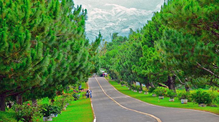
Pine trees lining the road to Don Salvador Benedicto Town
Don Salvador Benedicto, also known as Salvador Benedicto, is a 4th class municipality in the province of Negros Occidental, Philippines. The municipality is also dubbed as "The Summer Capital of Negros Occidental" due of its climate, which is similar to Baguio City.

The town of Salvador Benedicto is located at the mid-center of the hinterland of the entire north of the province of Negros Occidental. It lies 47 kilometers from the provincial capitol. The town was created by merging all the secluded barangays of San Carlos City and the towns of Calatrava and Murcia that were said to be ignored because of its distance and inaccessibility.
On February 9, 1983, the foundation of the town was completed upon the consent and authorization of Batas Pambansa Blg. 336 under the late Pres. Ferdinand Marcos. The legislation was authored by Assemblymen Alfonso Garcia and Jose Varela, Jr.
The town is named after the late Vice Governor Salvador Benedicto who took a vital part in the creation of the Revolutionary Government during World War II Japanese Occupation in Negros Island, mainly in Brgy. Igmaya-an.
The territorial formation of Don Salvador Benedicto is composed of two barangays from the Municipality of Murcia (Pandanon and Igmayaan), three barangays from the City of San Carlos (Kumaliskis, Bunga, and Pinowayan-Prosperidad) and two barangays from the Municipality of Calatrava (Bagong Silang-Marcelo and Bago-Lalong).
Sixty percent of the residents speak Cebuano and the rest speak Ilonggo and other dialects. The people have adopted the art of "kali" otherwise known as arnis or escrima as their cultural heritage. The traditional martial arts of the Filipino people since the 7th century, it is designed for physical training, mental development and spiritual upliftment as well as strengthening of the moral value foundation. The craft is highlighted every year during the celebration of the Kali-Kalihan Harvest Festival that also showcases various cultural and traditional activities of the people.
Famous and Historical Attractions
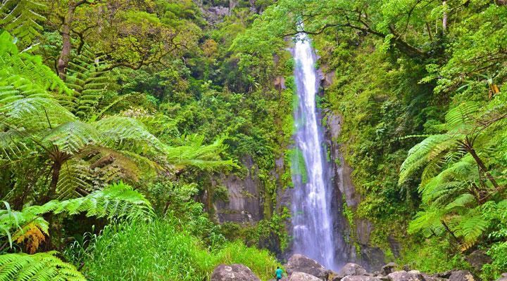
- Viewing Deck or Lantawan is overlooking the Malatan-og waterfalls, a cigarette falls that has charmed visitors to keep coming back.
- Villa Ica. This exquisitely landscaped area is a place where one can escape the busy and tiring city life and here find serenity as one communes and enjoys the beauty of nature in a pollution-free environment. It is an ideal venue for themed garden weddings.
- Pine Trees. Beautifully-grown pine trees lined the main thoroughfares of about 1.7 kilometer stretch of road from Barangay Igmayaan to Poblacion proper which gained recognition as well-maintained and “pot-hole-free” road for the third quarter of 2002 in the whole Region 6.
- Barangay Igmaya-an was part of the Revolutionary Government in Negros Occidental during the Japanese Occupation of the Philippines in World War II.
- Monument of Don Salvador Benedicto-monument in honor of the late Vice-Governor Salvador Benedicto, the namesake of the municipality.
- Two mountain ranges of Mt. Mandalagan and Mt. Canla-on.
- Road that links Bacolod City to San Carlos City, Canla-on City, Sagay City, Municipality of Toboso and Municipality of Calatrava.
- Rice Terraces located downstream of Poblacion which more or less look like the rice terraces in Banawe.
- Climate condition chilling atmosphere of the entire Municipality that you will forget Baguio City (16 to 27 Celsius).
- Malatan-og Falls – Brgy. Kumaliskis
- Mount Sirab – Brgy. Igmaya-an (Proposed area for Construction of Retreat House prayer mountain site)
- Hanging Bridge – Brgy. Igmaya-an (45 meters length)
- Zigzag Road – Brgy. Pandanon-Brgy. Igmaya-an
- Magahod Cave – Brgy. Bunga (the biggest spring in the locality)
- Maglahos Cave – Brgy. Kumaliskis
- Ugmagay-ay Spring – Brgy. Bagong Silang
- Sunog Lake – Brgy. Kumaliskis
- Secret Falls – Benejewan, Brgy. Bunga
- Pakpak Cave – Buyog, Brgy. Bunga
- Guano Cave – Brgy. Pinowayan
- Tayao Falls – Brgy. Bago
- Japanese Garrison – Brgy. Pandanon
- Tuy-anan Falls – Brgy. Bunga
Famous Event
Kali-kalihan Harvest Festival every second week of February has adopted the art of “kali” also known as “arnis” or “escrima” as their cultural heritage. The festivities illustrate the various cultural and traditional activities of the people from the “Kali” dance parade, “Kali cultural presentations and Search for the “Diwata sang Kali” presented by creatively designed costumes made out of indigenous materials abundant in the area.
How to get there
From the Negros Occidental Tourism Website, Negros Occidental can be reached through its capital, the highly urbanized City of Bacolod, which is 55 minutes from Manila and 30 minutes from Cebu by air. By sea, it is an 18-hour cruise from Manila and one hour aboard sea crafts from Iloilo. By land-and-sea travel, it is seven hours from Cebu. From Dumaguete City in Negros Oriental, Bacolod is 5 hours away via Mabinay in the south, and via San Carlos City in the north: 6 hours via the coastal road and 5 hours via the Translink highway in Don Salvador Benedicto.
Big and medium-sized buses, both aircon and non-aircon, ply the northern and southern parts of the province, with terminals in Bacolod. Car rental services are available for travel to any point of the island. Air-conditioned, metered taxis are numerous in Bacolod, but the jeepney is still the most common means of transport among the towns and cities.
Getting there
Don Salvador Benedicto is approximately an hour’s drive from Bacolod City by public utility vehicles and about 45 minutes by private car.
- http://en.wikipedia.org/wiki/Salvador_Benedicto,_Negros_Occidental
- http://negros-occ.gov.ph/about-negros-occidental/cities-and-municipalities/municipalities/municipality-of-don-salvador-benedicto/
- http://www.donsalvadorbenedicto.gov.ph/content/about-don-salvador-benedicto
- http://www.negrosoccidentaltourism.com/?page_id=22

